It never crossed my mind that it was the Halloween weekend when we set out to climb Fengtou Ridge. And since I'd never climbed the ridge before I had no idea how challenging it would be. Quel surprise when this hike exposed us to some of the hairiest sections we've come across in years. In other words, it was just the thing to celebrate the scariest day of the year.
Fengtou Ridge, or Point, is part of the long ridge system that extends pretty much from southern Taipei all the way to the east coast. It's just east of the famous Huang Didian ridge, separated by a narrow river valley that long ago must have cut the ridge in half.
We started our hike in Pingxi, a former coal mining village along the Pingxi Small Rail Line.
The first part of the trail followed an old rail line that was once used to haul coal out of the area until the mid-80s. Lovely softwood forests dotted with the occasional stand of Japanese cedar hemmed us on both sides. Occassionally we caugght a glimpse of the ridge to the southwest.
The sweet clear Gualiaokeng Stream (瓜寮坑 )warbled below. This stream would make a wonderful little river tracing excursion for someone with kids or someone looking for a safe place to practise the sport.

In 15 minutes we reached an old coal mining area, with abandoned buildings and mine shafts. One shaft is filled almost to the top with water and we call it Gollum's Lair.
resize.jpg)
The trail narrowed after this and followed a crystal clear stream that the locals are restocking with fish. Efforts are paying off and you can easily spot a dozen or more fry and larger adults in the deeper pools.
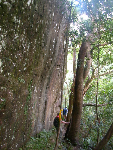
The signs for the turnoff to Fengtou Point were obvious but the first part of the trail was a bit tricky. In essence we had to clamber up a rather steep rocky slab for about 50m. It wasn't terribly difficult, but involved navigating around some boulders, and up a narrow cleft in the rock. It was good preparation for the really challenging bits later.
After the rocky slope the trail cut through a light forest until it reached the ridge proper. There were some astonishing views back toward the famous Pingxi crags. You can actually get to the top of this and other outcrops in the area on a series of steps cut into the stone. I've been to the top many times and will likely write about them another time.


The ridge looked like most others we have climbed: very thin but wooded even at the very top which tricks the eye into thinking you are not that high up. In other words, even though we were on less than a metre wide ridge top, with a drop of 200m on either side, we didn't feel it as the trees and shrubs that grew straight from the rock hemmed us in cozily.
At least at the start. It soon became apparent that this ridge was more exposed than others, and had almost no ropes or spikes for balance and safety. The day was a windy one and the gusts of high wind were annoying at first - and then worrisome.

After an hour or so of scrambling along, we stopped for lunch on the east peak, a rocky cap with a high slab back jutting up from the north side of the trail. We clambered up the slab to take advantage of some natural seats cut into the rock. It was a precarious spot, but the senery couldn't be better. Here we were only 30 minutes from Taipei but there was not a sign of development anywhere, just green rugged mountain ranges in all directions.

As we ate lunch a visitor dropped in, a middle aged Taiwanese man who was obviously a very experienced hiker. I don't know if he was showing off but he climbed up onto the pointiest part of the outcrop and strode over to where we were having lunch. This was insane. The ridge top here was literally a knife-edge. But he had astonishing balance and sang-froid. Far more than me who was nervous just having him around.
It was around 2pm at this point. We had been hiking since 11.30am. It was clear we were never going to finish the entire ridge. Fortunately our crazy visitor mentioned that a side trail branched off from the main ridge trail in about an hour and would take us back down to Pingxi.
I think we were all pretty glad of that as the trail was a bit more than we had expected. Silly us. The worst or best was yet to come.
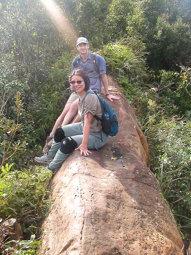
The pics we have don't show just how precariously we were situated. This one looks like we are happily sitting on a rock, but in fact, it is a bare stretch of ridge with sheer drop on both sides to the wooded valley below. We're sitting because no one wanted to walk across. The rock was not as dry as expected and it was windy as I said.

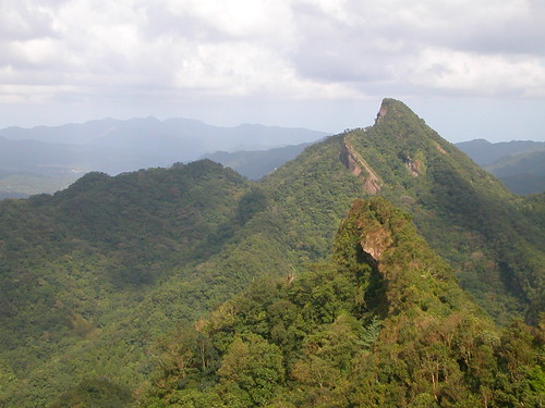
This is not a pic of Fengtou Point but it shows how thin and lofty these ridges can be and why the bare sections can really scare the crap out of you.

I suppose one of the reasons this hike was particularly unnerving was that we had never done it before and did not know what to expect. One of our members, Kate, is not a very experienced hiker, and struggled bravely to overcome her fears. She did
an admirable job but I was worried that we might come across a section that would prove too challenging for her - or all of us.
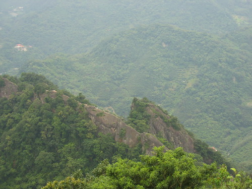
Fortunately the long bridge proved the worst of it and we made it to the branch in the trail around 3pm or so. The view of the ridge as it continued to run west was outstanding.
The trail down was very very steep and there were few ropes in place as is usual on Taiwanese trails (some trails are so steep you couldn't climb up or down without assistance). This made the going slow, but after the challenge of the ridge, it didn't seem at all difficult.
I love the type of low-altitude forest we climbed down through. It's not quite jungle but it's so luxuriant and so unlike anything I grew up with. We passed patches of acacias, you tong trees, bamboo, begonias, Chicken Shit Flowers, and a yellow puffy thing whose name escapes me.
The trail flattened out after a while and then crossed a saddle. The trail became overgrown in a few places but it was simple to follow as there were the ubiquitous ribbons on the branches. Taiwanese hiking groups hang these as markers and very often in this tropical land of quick growing plants and washouts, they are the only thing that marks a trail for long stretches.
In the last hour of the hike we unexpectedly found ourselves walking along the base of a towering grey cliff. It was very cool and quite a treat at the end of a long day to see something so beautifully rugged.

When the trail branched near the end we decided to head down to a small stream. We found a large man-made pool of clear water, which was obviously a catchment of sorts to collect water for piping down to the village. We would have gone for a swim in it had the day had much light left.
After a few seconds I suddenly knew where I was. This was the Gualiaokeng Stream and the trail that we had started on to the coal mining area was just above us. I hike in this area a lot and had been down to the pool many times but never from this direction which is why I didn't recognize it at first.
In any case, we crossed the pool, scrambled through a bamboo field to the trail and had a most satisfying amble back to the car along the old railway track line. It was about 5.30pm now and dusk was settling in the sky. I love this time of night here in Pingxi. Shuliangjian, which looks like a volcano, is particularly beautiful when its dark outline is set against an evening sky.
We decided to go for dinner in the area at a quaint little place set in an old Japanese era wood house. Chris brought the new Lonely Planet Taiwan guide into the restaurant and after dinner I read aloud passages. Everyone though it was pretty funny to attend a reading of a guidebook.
All in all this was one of the best hikes we've had. Though a little unnerving in places we'd all love do it again.
Practicalities:
Pinxi is south-east of Taipei. You can get there on by rail by taking a train to Ruifeng and then transferring to the Pingxi Small Rail Line (a nice ride) and getting off in Pingxi. There are also buses to Pingxi from Muzha MRT station. Just walk to the main road and cross. Buses 15 and 16 run every 30-60 minutes. A taxi from Muzha MRT is about NT400.
Once in Pingxi head up the road (the 106) just past the red brick school on the right. On the left you'll see a set of stairs with a map board. The map board is in English and Chinese. The trail system around here is all mapped and signposted at junctions so you won't get lost exploring.
The whole hike took us about 6 hours to complete. We only covered about 1/3 of the ridge. Taipei Day Trips by Richard Saunders covers the last 1/3.
Save this hike for a dry windless day with no chance of rain. Once on the ridge there is no way down for hours. It's a thrilling trek so make sure you and your group are up for it. Running shoes are probably better than hiking boots for grip.
Fengtou Ridge, or Point, is part of the long ridge system that extends pretty much from southern Taipei all the way to the east coast. It's just east of the famous Huang Didian ridge, separated by a narrow river valley that long ago must have cut the ridge in half.
We started our hike in Pingxi, a former coal mining village along the Pingxi Small Rail Line.
The first part of the trail followed an old rail line that was once used to haul coal out of the area until the mid-80s. Lovely softwood forests dotted with the occasional stand of Japanese cedar hemmed us on both sides. Occassionally we caugght a glimpse of the ridge to the southwest.
The sweet clear Gualiaokeng Stream (瓜寮坑 )warbled below. This stream would make a wonderful little river tracing excursion for someone with kids or someone looking for a safe place to practise the sport.

In 15 minutes we reached an old coal mining area, with abandoned buildings and mine shafts. One shaft is filled almost to the top with water and we call it Gollum's Lair.
resize.jpg)
The trail narrowed after this and followed a crystal clear stream that the locals are restocking with fish. Efforts are paying off and you can easily spot a dozen or more fry and larger adults in the deeper pools.
The signs for the turnoff to Fengtou Point were obvious but the first part of the trail was a bit tricky. In essence we had to clamber up a rather steep rocky slab for about 50m. It wasn't terribly difficult, but involved navigating around some boulders, and up a narrow cleft in the rock. It was good preparation for the really challenging bits later.
After the rocky slope the trail cut through a light forest until it reached the ridge proper. There were some astonishing views back toward the famous Pingxi crags. You can actually get to the top of this and other outcrops in the area on a series of steps cut into the stone. I've been to the top many times and will likely write about them another time.

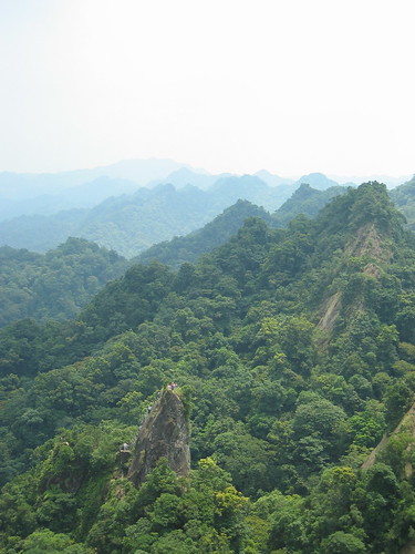
The ridge looked like most others we have climbed: very thin but wooded even at the very top which tricks the eye into thinking you are not that high up. In other words, even though we were on less than a metre wide ridge top, with a drop of 200m on either side, we didn't feel it as the trees and shrubs that grew straight from the rock hemmed us in cozily.
At least at the start. It soon became apparent that this ridge was more exposed than others, and had almost no ropes or spikes for balance and safety. The day was a windy one and the gusts of high wind were annoying at first - and then worrisome.

After an hour or so of scrambling along, we stopped for lunch on the east peak, a rocky cap with a high slab back jutting up from the north side of the trail. We clambered up the slab to take advantage of some natural seats cut into the rock. It was a precarious spot, but the senery couldn't be better. Here we were only 30 minutes from Taipei but there was not a sign of development anywhere, just green rugged mountain ranges in all directions.
As we ate lunch a visitor dropped in, a middle aged Taiwanese man who was obviously a very experienced hiker. I don't know if he was showing off but he climbed up onto the pointiest part of the outcrop and strode over to where we were having lunch. This was insane. The ridge top here was literally a knife-edge. But he had astonishing balance and sang-froid. Far more than me who was nervous just having him around.
It was around 2pm at this point. We had been hiking since 11.30am. It was clear we were never going to finish the entire ridge. Fortunately our crazy visitor mentioned that a side trail branched off from the main ridge trail in about an hour and would take us back down to Pingxi.
I think we were all pretty glad of that as the trail was a bit more than we had expected. Silly us. The worst or best was yet to come.
The pics we have don't show just how precariously we were situated. This one looks like we are happily sitting on a rock, but in fact, it is a bare stretch of ridge with sheer drop on both sides to the wooded valley below. We're sitting because no one wanted to walk across. The rock was not as dry as expected and it was windy as I said.
This is not a pic of Fengtou Point but it shows how thin and lofty these ridges can be and why the bare sections can really scare the crap out of you.
I suppose one of the reasons this hike was particularly unnerving was that we had never done it before and did not know what to expect. One of our members, Kate, is not a very experienced hiker, and struggled bravely to overcome her fears. She did
an admirable job but I was worried that we might come across a section that would prove too challenging for her - or all of us.
Fortunately the long bridge proved the worst of it and we made it to the branch in the trail around 3pm or so. The view of the ridge as it continued to run west was outstanding.
The trail down was very very steep and there were few ropes in place as is usual on Taiwanese trails (some trails are so steep you couldn't climb up or down without assistance). This made the going slow, but after the challenge of the ridge, it didn't seem at all difficult.
I love the type of low-altitude forest we climbed down through. It's not quite jungle but it's so luxuriant and so unlike anything I grew up with. We passed patches of acacias, you tong trees, bamboo, begonias, Chicken Shit Flowers, and a yellow puffy thing whose name escapes me.
The trail flattened out after a while and then crossed a saddle. The trail became overgrown in a few places but it was simple to follow as there were the ubiquitous ribbons on the branches. Taiwanese hiking groups hang these as markers and very often in this tropical land of quick growing plants and washouts, they are the only thing that marks a trail for long stretches.
In the last hour of the hike we unexpectedly found ourselves walking along the base of a towering grey cliff. It was very cool and quite a treat at the end of a long day to see something so beautifully rugged.
When the trail branched near the end we decided to head down to a small stream. We found a large man-made pool of clear water, which was obviously a catchment of sorts to collect water for piping down to the village. We would have gone for a swim in it had the day had much light left.
After a few seconds I suddenly knew where I was. This was the Gualiaokeng Stream and the trail that we had started on to the coal mining area was just above us. I hike in this area a lot and had been down to the pool many times but never from this direction which is why I didn't recognize it at first.
In any case, we crossed the pool, scrambled through a bamboo field to the trail and had a most satisfying amble back to the car along the old railway track line. It was about 5.30pm now and dusk was settling in the sky. I love this time of night here in Pingxi. Shuliangjian, which looks like a volcano, is particularly beautiful when its dark outline is set against an evening sky.
We decided to go for dinner in the area at a quaint little place set in an old Japanese era wood house. Chris brought the new Lonely Planet Taiwan guide into the restaurant and after dinner I read aloud passages. Everyone though it was pretty funny to attend a reading of a guidebook.
All in all this was one of the best hikes we've had. Though a little unnerving in places we'd all love do it again.
Practicalities:
Pinxi is south-east of Taipei. You can get there on by rail by taking a train to Ruifeng and then transferring to the Pingxi Small Rail Line (a nice ride) and getting off in Pingxi. There are also buses to Pingxi from Muzha MRT station. Just walk to the main road and cross. Buses 15 and 16 run every 30-60 minutes. A taxi from Muzha MRT is about NT400.
Once in Pingxi head up the road (the 106) just past the red brick school on the right. On the left you'll see a set of stairs with a map board. The map board is in English and Chinese. The trail system around here is all mapped and signposted at junctions so you won't get lost exploring.
The whole hike took us about 6 hours to complete. We only covered about 1/3 of the ridge. Taipei Day Trips by Richard Saunders covers the last 1/3.
Save this hike for a dry windless day with no chance of rain. Once on the ridge there is no way down for hours. It's a thrilling trek so make sure you and your group are up for it. Running shoes are probably better than hiking boots for grip.

6 comments:
This is an excellent article, it depicts our experiences in details and brings all the feelings and the beauties of the scenic views I saw along the trail back to my mind.
Thanks, Kate. The formatting was a bit off when you read it and I hadn't done a final proofreading. All the little errors should be gone now.
That seem really interesting. How can I get into that membership? I will like to go hiking with you, too.
Hi,
I climbed Jade Mountain a couple years ago and took some great pictures. I'm trying to find anyone who might have a gpx or kml file lying around that they could send me so I can geotag my photos properly. Would you happen to have any such file?
Thanks in advance!
Jeremy
jeremy.joslin@gmail.com
Hi guys,
Sorry for the late replies, but I was in Australia last week. Jeremy sorry but I don't have the files you want though I will ask around. Gypsy, I post hikes on www.forumosa.com in the Events section. Anyone is welcome to join.
Robert
Post a Comment